Latest
| CDOM | QSDE | |
| Chlorophyll | µg/L | |
| Conductivity | S/m | |
| Depth | m | |
| Dissolved O2 | ml/l | |
| Nitrate | µM | |
| O2 Saturation | ml/l | |
| O2 % Saturation | % | |
| Salinity | PSU | |
| Temperature | °C | |
| Turbidity | NTU | |
| Battery Voltage | V |
| CDOM | QSDE | |
| Chlorophyll | µg/L | |
| Conductivity | S/m | |
| Depth | m | |
| Dissolved O2 | ml/l | |
| Nitrate | µM | |
| O2 Saturation | ml/l | |
| O2 % Saturation | % | |
| Salinity | PSU | |
| Temperature | °C | |
| Turbidity | NTU | |
| Battery Voltage | V |
![]()
![]()
LOBO-0023 Lower Columbia River
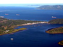
The Columbia River LOBO system was relocated on June 23, 2009 to a site further upstream in the Columbia River at mile marker 53, across from the Beaver Army Terminal. The Columbia River LOBO, a component of the CMOP STC center (NSF supported), was relocation in order to better quantify the Columbia River water quality conditions upstream of the Lower Columbia River estuary in coordination with the USGS. The new location of the LOBO mooring is 46 11.070N, 123 11.246W. On the LOBOviz data access page, you will be able to access the historical data (2008-2009) from the deployment in the Columbia River Estuary (46 11.442N, 123 44.801W) as well as the current deployment in the Lower Columbia River.
As a part of a collaborative research project to understand the health of the coastal ocean of the Pacific Northwest and the impacts of human activities, a LOBO system was installed in the lower Columbia River, near Astoria, OR. The LOBO system will be serving as an important biogeochemical data node within the Center for Coastal Margin Observation & Prediction (CMOP). CMOP is a multi-institutional National Science Foundation Science and Technology Center, that includes several academic and industry partners, including Oregon Health & Science University, Oregon State University, and University of Washington.
Configuration
46°11.070N 123°11.246W
Archived Data
Use LOBOviz to graph and download archived data from this LOBO node.
Other LOBO Systems
See other LOBO systems in action:
- SCCF RECON, Florida
- Northwest Arm, Nova Scotia
- Yaquina Bay, Oregon
- Penobscot River, Maine
- Elkhorn Slough, California
![]()
